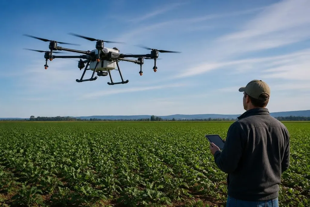
A farming drone can scan a field, carry a camera, or spread a treatment while flying above the crop. That changes the job from checking every row by hand to finding the parts of a field that need attention.
- Camera flights create maps that reveal gaps, standing water, and crop stress.
- Spray drones can reach areas that are wet, steep, or hard to enter with a tractor.
- The main limits are battery time, weather, local rules, and the quality of the data.
What the drone actually does
The aircraft carries a flight controller, motors, batteries, and a sensor or spray tank. A basic RGB camera records the same red, green, and blue light that a normal camera sees. That image can show missing plants, weeds, damaged leaves, and changes in field cover.
Some drones carry multispectral cameras. These sensors record extra bands of light that people cannot see, then turn the readings into maps. The map may point to crop stress, but it doesn't explain the cause by itself. Water shortage, pests, disease, and poor soil can produce similar signs.
Thermal cameras add heat data. A warmer patch may need a closer check, especially when the farmer compares it with nearby rows under similar conditions. The drone finds the patch; a person still needs to inspect the plant and soil before choosing a treatment.
Where the work changes
A drone can inspect a large area without sending a person across the whole field. That matters after rain, when a vehicle could damage wet soil or leave deep tracks between rows. It also helps when the field has slopes, narrow paths, or sections blocked by standing water.
Spray drones handle a different task. They carry a liquid tank and release small amounts over a planned area. The aircraft can treat a marked section instead of sending a tractor across the full field, but wind can move droplets away from the target. Operators need to follow the product label and local aviation and farm rules.
The useful change is the smaller work area. A grower can inspect or treat a section, check the result, and decide what to do next. That process can reduce wasted trips, but the drone doesn't remove the need for field records or human checks.
Data is where value is won or lost
A flight creates images, location data, or both. Software then joins the images into a field map, often using GPS data to place each image in the right position. A map has value only when someone can connect it to a task, such as checking a blocked irrigation line or counting missed plants.
That makes the workflow matter as much as the aircraft. The operator needs a flight plan, clear images, a way to mark problem areas, and a record of what happened after the visit. A pile of images on a laptop doesn't help a farm decide which row needs work.
The wider robotics record helps put farming drones in context. Agriculture robotics coverage from Robot24.com can connect a drone’s images and flight plan to the field task that follows. For a farm operator, that matters when aerial images point to a dry patch but a person still needs to check the soil and choose the response.
The limits on a farm
Battery capacity limits how long a drone can stay in the air. Larger spray loads add weight, while heavier equipment can reduce flight time. A farm may need spare batteries, charging gear, and a safe place to prepare the aircraft between flights.
Weather can stop a plan before the drone leaves the ground. Wind affects spray patterns and image quality. Rain can damage equipment, and bright or changing light can make images harder to compare across separate flights.
The data also needs care. A map can mark a problem without proving what caused it. If the operator acts on every color change, the farm may spend money on areas that were never at risk.
The best use is a short loop: fly, check the plants, act on a confirmed problem, and record the result.
I'd buy into a farming drone only when the farm has a clear job for each flight and a person who can check the findings.
A practical buying and use checklist
Before choosing a drone, check these points:
- Name the task: Decide if the aircraft will map crops, inspect plants, or spray.
- Check the payload: Confirm that the camera or tank fits the aircraft's weight limit.
- Plan the data: Choose where images will be stored and who will review them.
- Measure the field: Match flight time and battery changes to the area covered per trip.
- Check local rules: Confirm pilot, airspace, chemical, and privacy requirements before work begins.
- Set a follow-up: Decide how someone will inspect a marked area and record the result.
The next step for farming drones is connecting each flight to a clear farm decision, rather than sending them higher. A drone that finds a problem but leaves nobody able to act on it is still an aircraft, not a working farm tool.